Mountain Valley Pipeline
Based on Virginia Scientist-Community Interface Public Comment (October 27, 2021)
Environmental Justice Communities along Pipeline
Although a complete EJ community distribution along the entire pipeline route is not available, the VSC-I public comment did identify EJ communities in the county of Pittsylvania and Montgomery. Specifically, census tract 105, block 1 in Pittsylvania County has 23.48% Black or African American, which is greater than the 31.0% of the Virginia Commonwealth. Besides, census tract 214, block 1 in Montgomery and census tract 102, block 4 in Pittsylvania were identified as low-income EJ communities with 67.32% and 52.19% of households living below 80% of the county level median income.
Impacts on Water and Environmental Justice
- Potential siltation and pollution of steams due to construction
- As water tables are high in the Appalachian Valley and Ridge region, the pollution of streams and surface waters can affect groundwater, especially considering that 100 springs or domestic wells are within 150 feet of the pipeline
- The pipelines have been treated with 3M Scotchkote Fusion Bonded Epoxy 6233, a coating that contains chemical recognized as carcinogens. If ingested, these substances can pos risks of birth defects and other potential health consequences. When the coating is in contact with water, 77% of it can be leach from the surface of the pipelines. Meanwhile, the coating can also degrade in 30 days when exposed to sunlight, wind, and rain
Community-led Movement to Stop the Construction of the Pipeline
There are community groups and allied organizations continue to push back against the Mountain Valley Pipeline project, check the Appalachian Voices to learn more and get involved
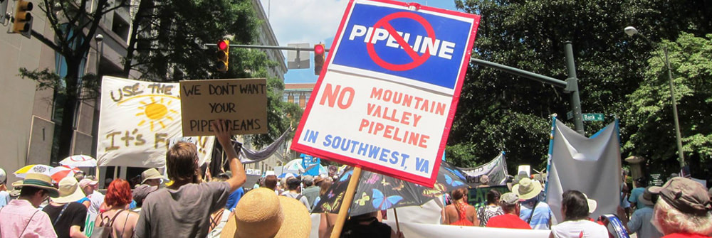
Image from Appalachian Voices
Radford Army Ammunitions Plant
|
The Radford Army Ammunition Plant (RAAP) is a government-owned, contractor-operated facility located in Radford, Virginia, United States. It was established in 1941 during World War II to support the war effort by manufacturing and storing ammunition. It is located in close proximity to the city of Radford, which has a population of approximately 16,000 people. The plant is situated on the New River, which is a major tributary of the Ohio River and a popular destination for outdoor recreation activities, such as fishing and kayaking. The close proximity of the RAAP to the city and the New River has raised concerns about the potential impact of the plant's operations on public health and the environment.
The RAAP has a history of releasing pollutants into the air, water, and soil in the surrounding environment. These releases have the potential to pose risks to public health and the environment. The practice of open burning (OB) of propellants and open detonation of munitions (OD) at the RAAP release a multitude of harmful compounds into the local environment. It can result in the release of smoke, particulate matter, nitrogen oxides, carbon monoxide, and heavy metals such as arsenic, lead, cadmium, copper, etc. into air which can travel to surrounding neighborhoods unchecked. Exposure to these pollutants can lead to cancer and other respiratory problems, including asthma and chronic bronchitis, as well as cardiovascular disease.
The RAAP has also been known to release pollutants into the water through its wastewater discharges. Perchlorate, which is a component of rocket fuel and can contaminate groundwater and surface water, and trichloroethylene (TCE), has been detected in the water near the plant. |
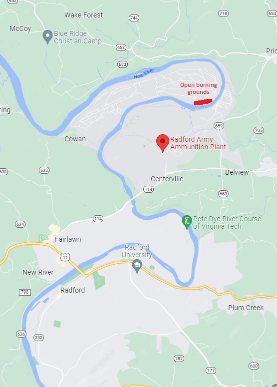
Map of the Radford Armory Ammunition Plant, Radford, Virginia.
Source: Google Maps
|
For more up-to-date information regarding the discharges from the RAAP can be found at the publicly available Enforcement and Compliance History Online database maintained by the EPA here. Detailed air, and water quality reports can also be found on hyperlinked on the same page. These reports contain information about the release of all reported compounds in pounds per year (unless otherwise specified).
Exceedance events at the RAAP refer to instances where the levels of pollutants released by the facility exceed the permitted limits set by environmental regulations. These events can include exceedances of air emissions, water discharges, or hazardous waste management practices. Exceedances can result in enforcement actions by regulatory agencies, including fines or other penalties. A detailed timeline of exceedance events at the RAAP can be found in a report titled 'An Explosive Problem: The Radford Arsenal's Toxic operations' prepared by the Earthjustice’s Community Partnerships Program and the Center for Progressive Reform in partnership with Citizens for Arsenal Accountability.
Stroubles Creek: anthropogenic impacts
 1864 Surveyed Map of Upper Stroubles Creek (Source: VWRRC Special Report, Virginia Tech Newman Library Archives)
The first European settlers moved to the Stroubles Creek watershed and began using Stroubles Creek as a water source in the 1740s; however, the population did not start to really increase until the town of Blacksburg was founded in 1798. An increase in population and urbanization marked the beginning of many water quality issues in the Stroubles Creek watershed.
Until 1911 at the very earliest, Blacksburg had no sanitary sewage system set up for the town, so raw sewage was being dumped directly into the Stroubles Creek (1911 Annual Report of the Commissioner of Health to the Governor of Virginia). Water quality testing was not standard practice at that time nor were there water quality standards or regulations, so the exact severity of the water quality damage and degradation is unknown. However, it was reported that there were high amounts of bacteria present, most likely E. coli.
In 1937, the Virginia Tech Drillfield was constructed resulting in the main branch of the Stroubles Creek being converted to an underground culvert (VWRRC Special Report). The Duck Pond was also created at this same time. Throughout the 1800s-1930s, coal mining was a very prominent business in the area, and coal mining wastewater frequently contaminated the watershed. From 1970-1978, there are reports of Virginia Tech chemistry labs discharging lab waste directly into the Duck Pond, and in 1985, large amounts of kerosene were spilled into the Duck Pond, as well. Ten years later after a severe flood event hit Blacksburg, the town decided that it was time to implement new stormwater planning designs.
In 1937, the Virginia Tech Drillfield was constructed resulting in the main branch of the Stroubles Creek being converted to an underground culvert (VWRRC Special Report). The Duck Pond was also created at this same time. Throughout the 1800s-1930s, coal mining was a very prominent business in the area, and coal mining wastewater frequently contaminated the watershed. From 1970-1978, there are reports of Virginia Tech chemistry labs discharging lab waste directly into the Duck Pond, and in 1985, large amounts of kerosene were spilled into the Duck Pond, as well. Ten years later after a severe flood event hit Blacksburg, the town decided that it was time to implement new stormwater planning designs.

Source: VWRRC Special Report
|
Source: VWRRC Special Report
|
Since 1995, Stroubles Creek has been listed as impaired on five separate occasions, three of which by Section 303(d) Total Maximum Daily Load (TMDL) Priority List and Reports due to violations of the state’s General Benthic Standard (TMDL Project Closeout Report: Stroubles Creek Watershed). These three years were 1996, 1998, and 2002 while the other two impairments were for recreational use caused by high amounts of E. coli in 2006 and 2010 (2020 305(b)/303(d) Water Quality Assessment Integrated Report). These two impairment listings required the city of Blacksburg to create state-mandated cleanup plans. In 2003, a TMDL analysis was completed and its results showed that the primary stressor impairing aquatic life was sediment (TMDL Project Closeout Report: Stroubles Creek Watershed). A TMDL Implementation Plan was then created in 2006 that identified a list of 10 TMDL stressors: lack of streamside forest, increasing development and peak flows from stormwater runoff, livestock access to streams, sewer overflows, agricultural runoff, improper disposal of grass clippings and trash, stream channel modifications, downtown business wastewater disposal, pollutant buildup on impervious surfaces, and lack of enforcement of erosion and sediment regulation at construction sites. Five best management practices were implemented with the goal of reducing 59% of sediment: establishment of riparian buffers, implementation of stormwater management measures and bioretention areas, sanitary sewer system improvements, exclusion of livestock from riparian corridors, and restoration of stream channels. These implementation projects were active from 2006-2014 until TMDL revisions were made, and then additional project was implemented from 2014-2017 and 2018-2023.
