What is Land Use?
- ““Land use” is the term used to describe the human use of land. It represents the economic and cultural activities (e.g., agricultural, residential, industrial, mining, and recreational uses) that are practiced at a given place.” - EPA (2022)
Why should we care?
How land is currently used plays a major role in what activities can take place on the land (e.g., development, agriculture, recreation, timber harvest, mining), and it can provide insight into what environmental concerns may be present in an area. Historical land use can provide a deeper understanding of environmental and social injustices of the past. It can also help us understand the lasting effects that certain types of land use can have on the people and the local environment today.
Who determines how land can be used?
In short, the landowner decides how their land can be used, but even this has some cavoites. Land ownership falls into two general categories: public and private land.
Public land is owned by the local, state, or federal government, and there are typically restrictions on what the land can be used for. For example, national forests are federally owned land managed by the U.S. Forest Service under the U.S. Department of Agriculture, and they are defined as a “working landscape.” This means that, in specific areas, private companies can pay the federal government to use the land for timber harvesting. Similarly, certain areas can be rented out by farmers to allow grazing for livestock. Meanwhile, the majority of land is open to the public for recreational purposes, such as hunting, fishing, hiking, biking, camping, and climbing.
Private land can be owned by individuals, organizations, or private companies. Privately owned land has much fewer restrictions on how it can be used. Activities on private land can have potentially negative environmental impacts that affect an area beyond that parcel of land. An example would be a mining operation, agricultural field, or urban area that contaminates drinking water of nearby residents.
Land Uses in the NRV
Coal Mining
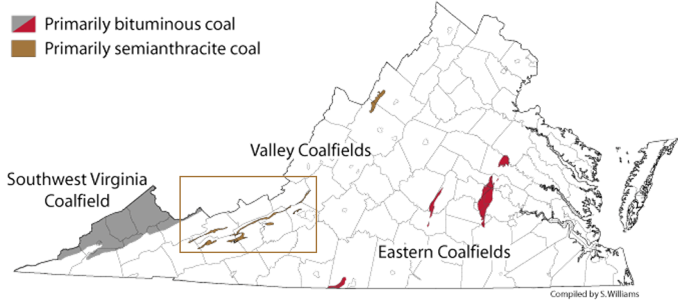
The Central Appalachians are rich in coal reserves. The New River Valley is home to the Valley Coalfields, which primarily stretches across Craig, Roanoke, Montgomery, Pulaski, Bland, and Wythe Counties. Historically, Giles County has one of highest densities of coal mines in the Commonwealth. [1]
The Central Appalachians are rich in coal reserves. The New River Valley is home to the Valley Coalfields, which primarily stretches across Craig, Roanoke, Montgomery, Pulaski, Bland, and Wythe Counties. Historically, Giles County has one of highest densities of coal mines in the Commonwealth. [1]
Source: http://www.virginiaplaces.org/geology/coal.html
The counties with historically highest density of coal mines are bolded. The red arrow points to Giles County, which is a part of the NRV.
Source: http://www.virginiaplaces.org/geology/coal.html
Logging
From the 1880s-1900s, the forests of Southern and Central Appalachia were heavily logged by private logging companies in an unsustainable manner. Entire mountainsides were often clearcut and then burned. These practices had serious consequences on the landscape and rivers due to substantial erosion of the hillsides. Rivers that would normally flow year-round would go completely dry in autumn and become raging rivers in spring, leading to significant flooding. Flooding in vital navigable rivers, including the Monongahela (WV, PA) and Ohio Rivers (PA, OH, WV, KY), both of which the New River Valley drains into, became so severe due to unsustainable logging practices that the federal government established federally owned Forest Reserves in the East managed by the U.S. Forest Service in 1911. These Forest Reserves are now known as National Forests, and sustainable management by the U.S. Forest Service has had major benefits on ecosystem health and has helped reduce the damage caused by flooding in the region. [2]
From the 1880s-1900s, the forests of Southern and Central Appalachia were heavily logged by private logging companies in an unsustainable manner. Entire mountainsides were often clearcut and then burned. These practices had serious consequences on the landscape and rivers due to substantial erosion of the hillsides. Rivers that would normally flow year-round would go completely dry in autumn and become raging rivers in spring, leading to significant flooding. Flooding in vital navigable rivers, including the Monongahela (WV, PA) and Ohio Rivers (PA, OH, WV, KY), both of which the New River Valley drains into, became so severe due to unsustainable logging practices that the federal government established federally owned Forest Reserves in the East managed by the U.S. Forest Service in 1911. These Forest Reserves are now known as National Forests, and sustainable management by the U.S. Forest Service has had major benefits on ecosystem health and has helped reduce the damage caused by flooding in the region. [2]

Source: http://npshistory.com/publications/usfs/region/8/history/chap1.htm
|

Source: http://npshistory.com/publications/usfs/region/8/history/chap1.htm
|
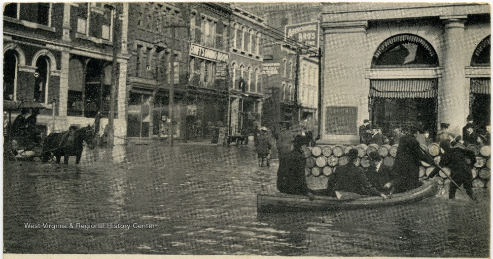
The 1907 Pittsburg flood was largely due to unsustainable logging practices. In present-day value, the damages amounted to over $3.2 billion. Even though Pittsburg is approximately 300 miles north of the NRV, the logging practices in this area contributed to this devastating flood. Source: https://twitter.com/WVUHistoryDept/status/1239582196286935042/photo/2
|
Agriculture
In 1900, a larger number of Virginians were farmers, and roughly 73% of the state was farmland. Today, there are only one quarter as many farms, and farmland only accounts for 30% of the state's land area [3]. Even though farming in Virginia is not as widespread as it once was, there are still many farmers in the state, and their farming practices have changed dramatically over time. Similar to the early days of the logging industry, farming practices in the late 1800s and early 1900s were largely unsustainable resulting in severe erosion and the loss of productive topsoil. While practices have since improved in regard to erosion-control and maintaining soil health, the widespread use of chemical fertilizers over the past few decades now imposes major water quality threats to local streams, such as Stroubles Creek, all the way up the entire Chesapeake Bay. The excess fertilizer runs off the land and into the waterways leading to nutrient pollution, which can have negative effects on human and environmental health. Nutrient pollution can also inflict serious economic damage to local communities that rely on fishing or outdoor recreation as major sources of revenue, and cleaning the water so that it is drinkable can cost local water treatment plants millions of dollars [4]. |
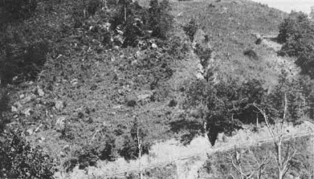
Severely eroded hillside as a result of poor farming practices in 1901. Source: http://npshistory.com/publications/usfs/region/8/history/chap1.htm
|
Urban Development
Compared to the rest of the Commonwealth, the NRV has experience minimal urban development with the majority concentrated in a few towns. Blacksburg is the largest town in the NRV with 44,949 people and a population density of 2,274 people per square mile [5]. Generally speaking, the counties that are often referred to as comprising the NRV (Montgomery, Pulaski, Wythe, Carol, Giles, Floyd, Grayson, and Bland) are amongst the least densely populated in the state. Montgomery county is the 47th out of 132 counties, but it is the exception. The remaining counties fall between the 62nd densest (Pulaski) and 128th (Bland) [6].
Even though the NRV does not have dense urban centers like other parts of the Commonweath, urban development still occurs and can negatively impact the local environment. The construction of new buildings, roads, and other infrastructure can lead to deforestation, habitat loss, and a reduction in biodiversity. It can also contribute to air and water pollution, climate change, and other environmental problems. Additionally, urban areas often experience the urban heat island effect, which can lead to higher temperatures and increased energy consumption for cooling [7].
Industrialization
The NRV is home to a variety of industries with the primary sectors being automobile manufacturing, chemical processing, and plastics and materials processing [8]. These industries are important to the NRV as they employ thousands of residents and help support economic prosperity within the region. However, chemical and plastic production and processing have the potential inflict major environmental damages when toxic substances get released into the environment either through the water or air, which can seriously harm wildlife and human health.
The NRV is home to a variety of industries with the primary sectors being automobile manufacturing, chemical processing, and plastics and materials processing [8]. These industries are important to the NRV as they employ thousands of residents and help support economic prosperity within the region. However, chemical and plastic production and processing have the potential inflict major environmental damages when toxic substances get released into the environment either through the water or air, which can seriously harm wildlife and human health.
Industrial manufacturing in the NRV is not limited to the private sector. The U.S. military has historically had a significant presence in Virginia, and this holds true for the NRV, which is home to a large ammunitions manufacturer, the Radford Army Ammunition Plant, informally known as the Radford Armory. For decades, the Radford Armory has disposed of much of their waste, consisting largely of chemical propellants, through open pit burning on their grounds [9]. In recent years, this has raised major air and water quality concerns in the area. Learn more about this about the Radford Amory and this environmental justice concern on our Air Quality and Case Studies pages.
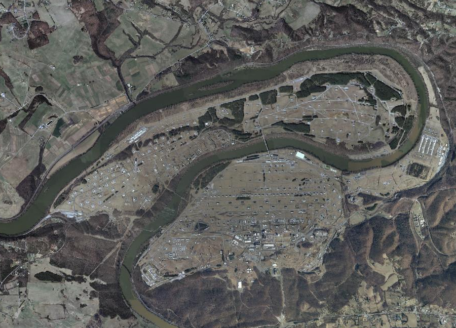
Aerial view of the Radford Army Ammunition Plant near along the New River near Radford, VA in Pulaski and Montgomery counties. Source: http://www.virginiaplaces.org/military/radford.html
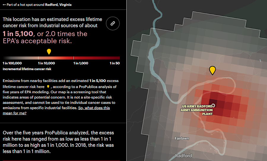
Source: http://www.virginiaplaces.org/military/radford.html. Original source for interactive air quality map: https://projects.propublica.org/toxmap/
Land Conservation in the NRV
This section is under construction. Please, check back later. :)
References
This section is under construction. Please, check back later. :)
This section is under construction. Please, check back later. :)
